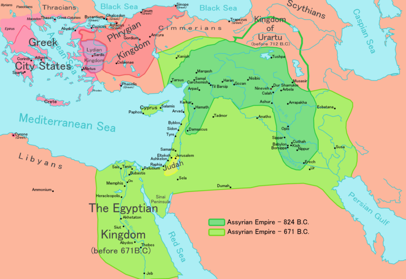
File:Map of Assyria.png

Size of this preview: 800 × 550 pixels. Other resolutions: 320 × 220 pixels | 640 × 440 pixels | 1,024 × 704 pixels | 1,280 × 880 pixels | 1,983 × 1,363 pixels.
Original file (1,983 × 1,363 pixels, file size: 160 KB, MIME type: image/png)
File history
Click on a date/time to view the file as it appeared at that time.
| Date/Time | Thumbnail | Dimensions | User | Comment | |
|---|---|---|---|---|---|
| current | 12:32, 24 Mei 2018 |  | 1,983 × 1,363 (160 KB) | Capmo | corrected typos in Trapezus and Hamath |
| 18:33, 12 Hepetema 2010 |  | 1,983 × 1,363 (148 KB) | Ras67 | cropped and squeezed | |
| 00:35, 1 Hepetema 2010 |  | 1,985 × 1,365 (161 KB) | Capmo | typo in word "Aegean"; 256 colors | |
| 21:05, 21 Hānuere 2010 |  | 1,985 × 1,365 (645 KB) | Megistias | Border around map, Details | |
| 14:51, 26 Pēpuere 2006 |  | 1,985 × 1,365 (640 KB) | Ningyou | This is a large map of Assyria, made by Ningyou. For translations of this map, contact Ningyou. Category:Assyria |
File usage
The following page uses this file:
Global file usage
The following other wikis use this file:
- Usage on af.wikipedia.org
- Usage on als.wikipedia.org
- Usage on am.wikipedia.org
- Usage on an.wikipedia.org
- Usage on arc.wikipedia.org
- Usage on ar.wikipedia.org
- Usage on ast.wikipedia.org
- Usage on azb.wikipedia.org
- Usage on az.wikipedia.org
- Usage on ba.wikipedia.org
- Usage on be.wikipedia.org
- Usage on bg.wikipedia.org
- Usage on bn.wikipedia.org
- Usage on ckb.wikipedia.org
- Usage on cs.wikipedia.org
- Usage on cv.wikipedia.org
- Usage on cy.wikipedia.org
- Usage on dag.wikipedia.org
- Usage on da.wikipedia.org
- Usage on de.wikipedia.org
- Usage on el.wikipedia.org
- Usage on en.wikipedia.org
View more global usage of this file.


