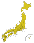
File:Japan prefectures.png
Japan_prefectures.png (300 × 383 pixels, file size: 17 KB, MIME type: image/png)
File history
Click on a date/time to view the file as it appeared at that time.
| Date/Time | Thumbnail | Dimensions | User | Comment | |
|---|---|---|---|---|---|
| current | 13:28, 25 Hepetema 2004 |  | 300 × 383 (17 KB) | Robbot | This image was copied from en.wikipedia.org. The original description was: Map of the Prefectures of Japan. Made by Golbez based on the existing prefectural maps on Wikipedia. {{GFDL}} en:Image:Japan prefectures.png |
File usage
Kāhore kau ngā whārangi e whai hoto ana ki tēnei kōnae whakaahua.
Global file usage
The following other wikis use this file:
- Usage on ar.wikipedia.org
- Usage on ay.wikipedia.org
- Usage on azb.wikipedia.org
- Usage on be.wikipedia.org
- Usage on bg.wikipedia.org
- Usage on ca.wikipedia.org
- Usage on cv.wikipedia.org
- Usage on da.wikipedia.org
- Usage on de.wikipedia.org
- Usage on de.wikinews.org
- Usage on de.wikivoyage.org
- Usage on eo.wikipedia.org
- Usage on es.wikipedia.org
- Jardín Botánico de Kioto
- Jardín Botánico Alpino del Monte Rokko
- Awaji Yumebutai
- Jardín de Hierbas Silvestres de la Ciudad de Sendai
- Jardín Botánico de la Universidad de Hokkaidō
- Jardín Botánico Koishikawa
- Jardín Botánico Jindaiji
- Jardín Botánico Nikko
- Jardín Botánico de Hiroshima
- Jardín Botánico Makino
- Rosaleda Aramaki
- Zoológico y Jardín Botánico Higashima
- Estación de Investigación de Oita
- Jardín Botánico de Akatsuka
- Aritaki Arboretum
- Jardín Botánico de la Universidad de Osaka
- Jardín de Bambú Fuji
- Jardín Botánico de Toyama
- Estación Experimental de Plantas para Paisajes
- Jardín Botánico de Humedales de Hakone
- Jardín Botánico Tegarayama de Ciudad Himeji
- Jardín Botánico de la Universidad Tohoku
- Jardín Botánico Mito
- Jardín de Plantas Medicinales de la Universidad de Ciencias de la Salud de Hokkaido
- Jardín Botánico Acuático Mizunomori
- Jardín de Plantas Medicinales de la Universidad de Farmacia de Tohoku
- Jardín de Plantas Medicinales de la Escuela de Farmacia Hoshi
- Jardín Nacional Shinjuku Gyoen
- Jardín Metropolitano de Tokio de Plantas Medicinales
View more global usage of this file.


