File:Fulton County Georgia Incorporated and Unincorporated areas Atlanta Highlighted.svg

Size of this PNG preview of this SVG file: 675 × 600 pixels. Other resolutions: 270 × 240 pixels | 540 × 480 pixels | 864 × 768 pixels | 1,152 × 1,024 pixels | 2,304 × 2,048 pixels | 900 × 800 pixels.
Original file (SVG file, nominally 900 × 800 pixels, file size: 277 KB)
| Description |
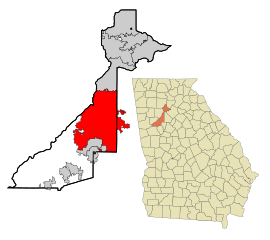
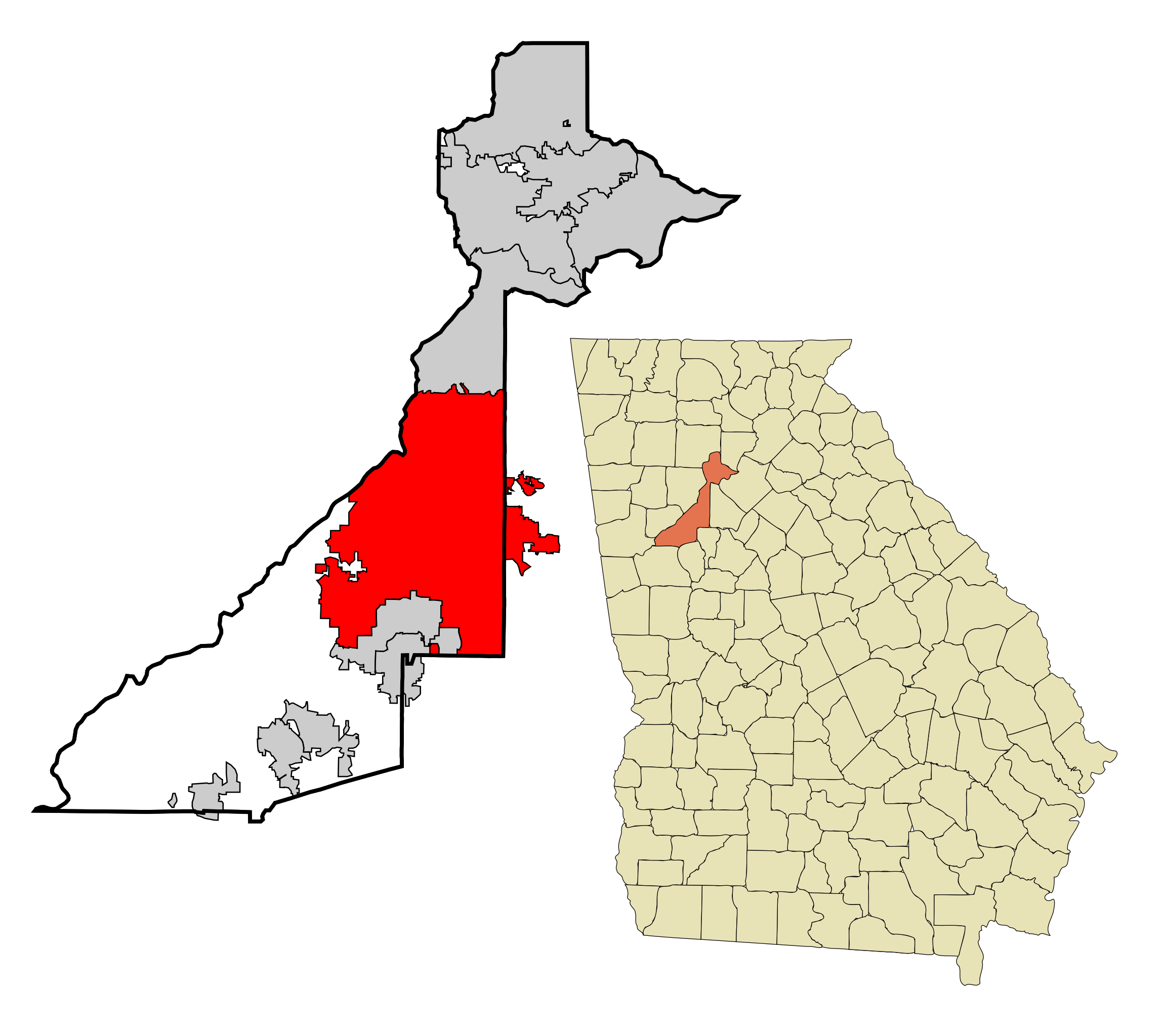
This map shows the incorporated and unincorporated areas in Fulton County, Georgia. Atlanta is highlighted in red.
|
| Date | |
| Source | My own work, based on public domain information. Based on similar map concepts by Ixnayonthetimmay |
| Author | Arkyan |
I, the copyright holder of this work, hereby publish it under the following licenses:

|
Permission is granted to copy, distribute and/or modify this document under the terms of the GNU Free Documentation License, Version 1.2 or any later version published by the Free Software Foundation; with no Invariant Sections, no Front-Cover Texts, and no Back-Cover Texts. A copy of the license is included in the section entitled GNU Free Documentation License. |
| This file is licensed under the Creative Commons Attribution-Share Alike 3.0 Unported license. | ||
| ||
| This licensing tag was added to this file as part of the GFDL licensing update. |
This file is licensed under the Creative Commons Attribution-Share Alike 2.5 Generic, 2.0 Generic and 1.0 Generic license.
- You are free:
- to share – to copy, distribute and transmit the work
- to remix – to adapt the work
- Under the following conditions:
- attribution – You must give appropriate credit, provide a link to the license, and indicate if changes were made. You may do so in any reasonable manner, but not in any way that suggests the licensor endorses you or your use.
- share alike – If you remix, transform, or build upon the material, you must distribute your contributions under the same or compatible license as the original.
You may select the license of your choice.
File history
Click on a date/time to view the file as it appeared at that time.
| Date/Time | Thumbnail | Dimensions | User | Comment | |
|---|---|---|---|---|---|
| current | 11:48, 12 Māehe 2018 | | 900 × 800 (277 KB) | Haha169 | Add a few more parcels, fix the boundaries of the Emory annexation to include the Dekalb fire station carve out |
| 09:59, 2 Hānuere 2018 |  | 900 × 800 (276 KB) | Haha169 | fix | |
| 03:12, 2 Hānuere 2018 |  | 900 × 800 (276 KB) | Haha169 | updated with new borders since 2007 | |
| 14:57, 26 Oketopa 2007 |  | 900 × 800 (279 KB) | ArkyBot~commonswiki | {{Information |Description=This map shows the incorporated and unincorporated areas in Fulton County, Georgia, highlighting Atlanta in red. It was created wit | |
| 20:56, 19 Hepetema 2007 |  | 900 × 800 (259 KB) | ArkyBot~commonswiki | {{Information |Description=This map shows the incorporated and unincorporated areas in Fulton County, Georgia, highlighting Atlanta in red. It was created wit |
File usage
The following page uses this file:
Global file usage
The following other wikis use this file:
- Usage on af.wikipedia.org
- Usage on ang.wikipedia.org
- Usage on ar.wikipedia.org
- Usage on arz.wikipedia.org
- Usage on ast.wikipedia.org
- Usage on bi.wikipedia.org
- Usage on br.wikipedia.org
- Usage on bs.wikipedia.org
- Usage on ca.wikipedia.org
- Usage on ceb.wikipedia.org
- Usage on de.wikipedia.org
- Usage on diq.wikipedia.org
- Usage on el.wikipedia.org
- Usage on en.wikipedia.org
- Usage on eo.wikipedia.org
- Usage on es.wikipedia.org
- Usage on et.wikipedia.org
- Usage on eu.wikipedia.org
- Usage on fa.wikipedia.org
- Usage on fr.wikipedia.org
- Usage on fy.wikipedia.org
- Usage on ga.wikipedia.org
- Usage on gl.wikipedia.org
- Usage on ha.wikipedia.org
- Usage on he.wikipedia.org
- Usage on ht.wikipedia.org
- Usage on hu.wikipedia.org
- Usage on ia.wikipedia.org
- Usage on id.wikipedia.org
- Usage on ie.wikipedia.org
- Usage on ilo.wikipedia.org
- Usage on it.wikipedia.org
- Usage on ja.wikipedia.org
- Usage on kab.wikipedia.org
- Usage on kn.wikipedia.org
- Usage on ko.wikipedia.org
- Usage on kw.wikipedia.org
- Usage on lad.wikipedia.org
- Usage on la.wikipedia.org
- Usage on lb.wikipedia.org
- Usage on ln.wikipedia.org
- Usage on ms.wikipedia.org
- Usage on my.wikipedia.org
- Usage on mzn.wikipedia.org
- Usage on nl.wikipedia.org
- Usage on nov.wikipedia.org
- Usage on no.wikipedia.org
- Usage on pcd.wikipedia.org
View more global usage of this file.