File:Cabinda pol77.jpg

Size of this preview: 455 × 599 pixels. Other resolutions: 182 × 240 pixels | 364 × 480 pixels | 583 × 768 pixels | 1,040 × 1,370 pixels.
Original file (1,040 × 1,370 pixels, file size: 160 KB, MIME type: image/jpeg)

|
File:Cabinda map-fr.svg is a vector version of this file. It should be used in place of this JPG file when not inferior.
File:Cabinda pol77.jpg → File:Cabinda map-fr.svg
For more information, see Help:SVG. |
 |
Summary
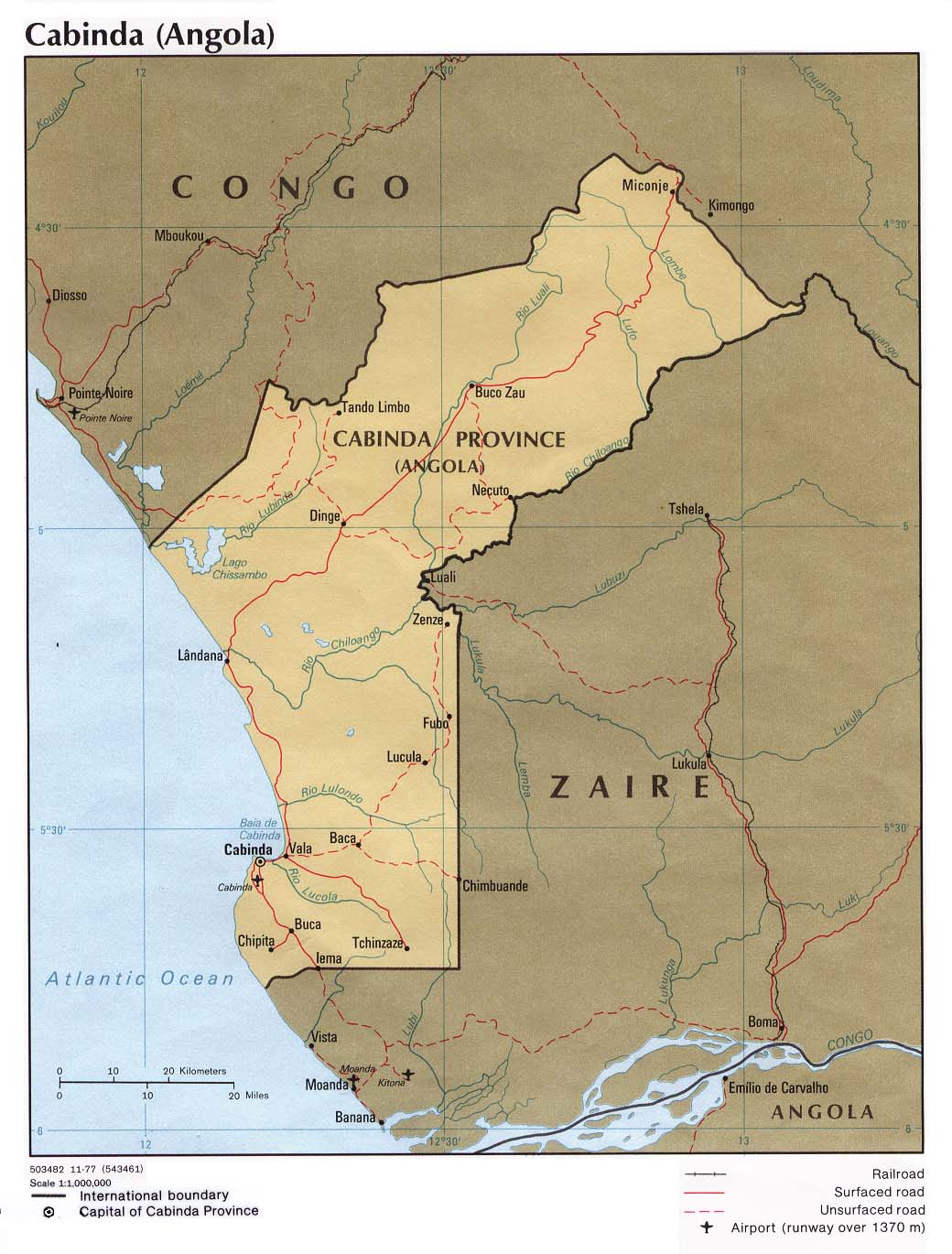
| Description | Political map of the Cabinda province, Angola. |
| Date | |
| Source | University of Texas Libraries, Perry-Castañeda Library Map Collection: Angola Maps |
| Author | CIA |
| Other versions | Derivative works of this file: Cabinda map-fr.svg |
Licensing
| This image is a work of a Central Intelligence Agency employee, taken or made as part of that person's official duties. As a Work of the United States Government, this image or media is in the public domain in the United States.
|

|
derivative works
File history
Click on a date/time to view the file as it appeared at that time.
| Date/Time | Thumbnail | Dimensions | User | Comment | |
|---|---|---|---|---|---|
| current | 18:34, 23 Āperira 2007 | | 1,040 × 1,370 (160 KB) | Kipala | http://www.lib.utexas.edu/maps/africa/cabinda_pol77.jpg From the Perry Castaneda Map Collection "Courtesy of the University of Texas Libraries, The University of Texas at Austin." |
File usage
Kāhore kau ngā whārangi e whai hoto ana ki tēnei kōnae whakaahua.
Global file usage
The following other wikis use this file:
- Usage on ar.wikipedia.org
- Usage on azb.wikipedia.org
- Usage on br.wikipedia.org
- Usage on ca.wikipedia.org
- Usage on co.wikipedia.org
- Usage on cy.wikipedia.org
- Usage on da.wikipedia.org
- Usage on de.wikipedia.org
- Usage on el.wikipedia.org
- Usage on en.wikipedia.org
- Usage on eo.wikipedia.org
- Usage on eo.wikivoyage.org
- Usage on es.wikipedia.org
- Usage on eu.wikipedia.org
- Usage on fa.wikipedia.org
- Usage on fi.wikipedia.org
- Usage on fo.wikipedia.org
- Usage on fr.wikipedia.org
- Usage on ha.wikipedia.org
- Usage on he.wikipedia.org
- Usage on hu.wikipedia.org
- Usage on it.wikipedia.org
- Usage on ka.wikipedia.org
- Usage on kg.wikipedia.org
- Usage on ko.wikipedia.org
- Usage on la.wikipedia.org
- Usage on ln.wikipedia.org
- Usage on lt.wikipedia.org
- Usage on mk.wikipedia.org
- Usage on nl.wikipedia.org
- Usage on nn.wikipedia.org
View more global usage of this file.